Using Open Sea Map data in Kibana maps
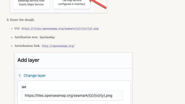
Read OriginalThis technical article explains how to add OpenSeaMap tile server data to Kibana's map visualizations. It details the process of configuring the Tile Map Service URL to display maritime details such as buoys, shipping lanes, and port information, which are not available in Kibana's default road maps. The guide is aimed at users working with geospatial data, particularly in maritime contexts, to enrich their data analysis dashboards.
0 comments
Comments
No comments yet
Be the first to share your thoughts!
Browser Extension
Get instant access to AllDevBlogs from your browser
Top of the Week
1
The Beautiful Web
Jens Oliver Meiert
•
2 votes
2
When your coding agent doesn’t understand your project, you’ll get junk
Benjamin Cane
•
1 votes
3
LLM Use in the Python Source Code
Miguel Grinberg
•
1 votes
4
Wagon’s algorithm in Python
John D. Cook
•
1 votes
5
An example conversation with Claude Code
Dumm Zeuch
•
1 votes