Maxar's HD Global Imagery Basemap
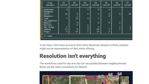
Read OriginalThis article provides a detailed technical examination of Maxar's HD Global Imagery Basemap, a 30cm resolution satellite imagery service. It covers the author's workstation setup (Intel i9, 96GB RAM, Ubuntu/WSL), the installation of prerequisites like GDAL, Python, and DuckDB with spatial extensions, and the methodology for analyzing 60GB of imagery data across eleven global cities using QGIS for map rendering.
Comments
No comments yet
Be the first to share your thoughts!
Browser Extension
Get instant access to AllDevBlogs from your browser
Top of the Week
1
The Beautiful Web
Jens Oliver Meiert
•
2 votes
2
When your coding agent doesn’t understand your project, you’ll get junk
Benjamin Cane
•
1 votes
3
LLM Use in the Python Source Code
Miguel Grinberg
•
1 votes
4
Wagon’s algorithm in Python
John D. Cook
•
1 votes
5
An example conversation with Claude Code
Dumm Zeuch
•
1 votes