Better Boundaries
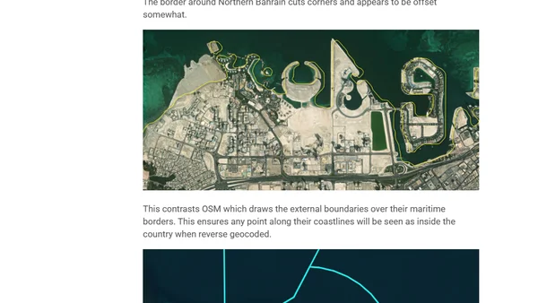
Read OriginalThis article provides a detailed technical comparison of several level-0 administrative boundary datasets, evaluating their geometric accuracy, country coverage, and metadata. It documents the author's workstation setup, software prerequisites (Python, DuckDB with extensions), and the process for downloading and analyzing OpenStreetMap's Parquet data dump, using QGIS for map rendering.
0 comments
Comments
No comments yet
Be the first to share your thoughts!
Browser Extension
Get instant access to AllDevBlogs from your browser
Top of the Week
1
The Beautiful Web
Jens Oliver Meiert
•
2 votes
2
When your coding agent doesn’t understand your project, you’ll get junk
Benjamin Cane
•
1 votes
3
LLM Use in the Python Source Code
Miguel Grinberg
•
1 votes
4
Wagon’s algorithm in Python
John D. Cook
•
1 votes
5
An example conversation with Claude Code
Dumm Zeuch
•
1 votes