Apple's DepthPro on Maxar's Imagery
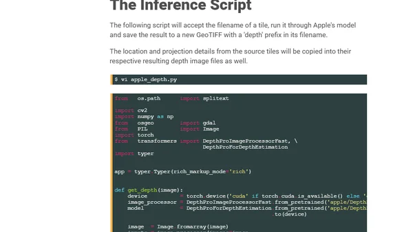
Read OriginalThis article provides a detailed technical tutorial on applying Apple's DepthPro machine learning model to analyze Maxar's 2025 satellite imagery of Bangkok. It covers the author's workstation specifications, software prerequisites (GDAL, Python, ArcGIS Pro), installation steps, and the process of downloading and processing the geospatial data to generate depth maps from satellite photos.
Comments
No comments yet
Be the first to share your thoughts!
Browser Extension
Get instant access to AllDevBlogs from your browser
Top of the Week
1
The Beautiful Web
Jens Oliver Meiert
•
2 votes
2
When your coding agent doesn’t understand your project, you’ll get junk
Benjamin Cane
•
1 votes
3
LLM Use in the Python Source Code
Miguel Grinberg
•
1 votes
4
Wagon’s algorithm in Python
John D. Cook
•
1 votes
5
An example conversation with Claude Code
Dumm Zeuch
•
1 votes