Ordnance Survey Data Importer Coordinate Conversion Accuracy
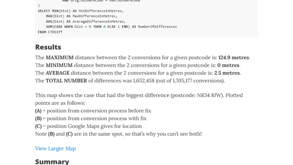
Read OriginalThis technical blog post details an analysis of an inaccuracy in a third-party GeoCoordConversion DLL used to transform Ordnance Survey Eastings/Northings coordinates to Latitude/Longitude for SQL Server import. The author quantifies the impact by comparing results from the original and corrected code, finding an average positional difference of 2.5 meters, and discusses the implications for the data project.
Comments
No comments yet
Be the first to share your thoughts!
Browser Extension
Get instant access to AllDevBlogs from your browser
Top of the Week
1
The Beautiful Web
Jens Oliver Meiert
•
2 votes
2
When your coding agent doesn’t understand your project, you’ll get junk
Benjamin Cane
•
1 votes
3
LLM Use in the Python Source Code
Miguel Grinberg
•
1 votes
4
Wagon’s algorithm in Python
John D. Cook
•
1 votes
5
An example conversation with Claude Code
Dumm Zeuch
•
1 votes